
Thank you for supporting this site ❤️
Make a donation
Make a donation
Gear up for your next adventure:
As an Amazon Associate, this site earns from qualifying purchases at no extra cost to you.
Poma topographic map
Click on the map to display elevation.
Thank you for supporting this site ❤️
Make a donation
Make a donation
Gear up for your next adventure:
As an Amazon Associate, this site earns from qualifying purchases at no extra cost to you.
About this map
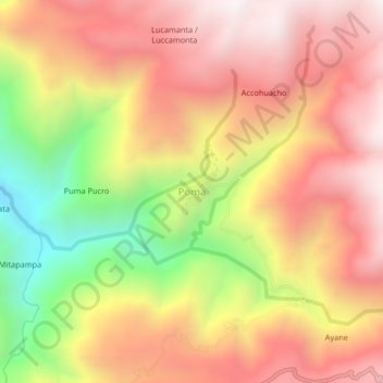
Name: Poma topographic map, elevation, terrain.
Location: Poma, Querobamba, Province of Sucre, Ayacucho, Peru (-13.99912 -73.84237 -13.95912 -73.80237)
Average elevation: 3,482 m
Minimum elevation: 2,763 m
Maximum elevation: 3,980 m
Thank you for supporting this site ❤️
Make a donation
Make a donation
Gear up for your next adventure:
As an Amazon Associate, this site earns from qualifying purchases at no extra cost to you.