Geolocate

Molteno topographic map

Click on the map to display elevation.

About this map
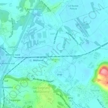
Name: Molteno topographic map, elevation, terrain.

Location: Molteno, Lecco, Lombardy, 23847, Italy (45.76845 9.28682 45.79496 9.31590)

Average elevation: 275 m

Minimum elevation: 260 m

Maximum elevation: 366 m

Other topographic maps

Click on a map to view its topography, its elevation and its terrain.

Regolo

Italy > Lombardy > Lecco > Gittana

Average elevation: 423 m

Vassena

Italy > Lombardy > Lecco > Oliveto Lario

Average elevation: 426 m

Monte Resegone

Italy > Lombardy > Lecco > Lecco

Average elevation: 1,371 m

Travecchia

Italy > Lombardy > Lecco > Ca' Nova

Average elevation: 387 m

Consonno

Italy > Lombardy > Lecco > Olginate

Average elevation: 486 m

Gear up for your next adventure:

🔋Lithium AA Batteries - Long-lasting power that performs in extreme cold
🧭GPS Outdoor Watch - Smart watch for navigation and fitness tracking in nature
⛺Camping Essentials - All-in-one gear for a comfortable camping trip
🧣Merino Neck Gaiter - Protects against wind, sun, and cold at high altitudes
🧶550 Survival Paracord - Versatile utility cord for emergency repairs and rigging

As an Amazon Associate, this site earns from qualifying purchases at no extra cost to you.