
Make a donation
Gear up for your next adventure:
As an Amazon Associate, this site earns from qualifying purchases at no extra cost to you.
Lephalale Local Municipality topographic map
Click on the map to display elevation.
Make a donation
Gear up for your next adventure:
As an Amazon Associate, this site earns from qualifying purchases at no extra cost to you.
About this map
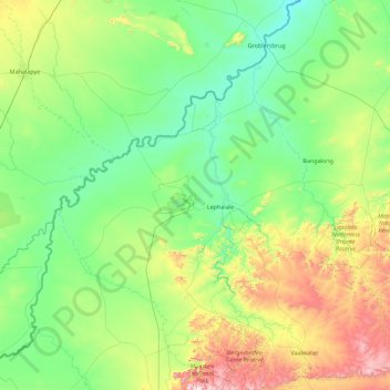
Name: Lephalale Local Municipality topographic map, elevation, terrain.
Average elevation: 991 m
Minimum elevation: 765 m
Maximum elevation: 1,916 m
Make a donation
Gear up for your next adventure:
As an Amazon Associate, this site earns from qualifying purchases at no extra cost to you.
Other topographic maps
Click on a map to view its topography, its elevation and its terrain.
Sekgakgapeng
South Africa > Limpopo > Waterberg District Municipality > Mogalakwena Local Municipality
Average elevation: 1,118 m
Modimolle
South Africa > Limpopo > Waterberg District Municipality > Modimolle Local Municipality
Average elevation: 1,192 m
Mogalakwena
South Africa > Limpopo > Waterberg District Municipality > Mogalakwena Local Municipality
Average elevation: 855 m
Make a donation
Gear up for your next adventure:
As an Amazon Associate, this site earns from qualifying purchases at no extra cost to you.
Bela-Bela
South Africa > Limpopo > Waterberg District Municipality > Bela Bela Local Municipality
Average elevation: 1,158 m
Thabazimbi
South Africa > Limpopo > Waterberg District Municipality > Thabazimbi Local Municipality
Average elevation: 1,077 m
Lephalale
South Africa > Limpopo > Waterberg District Municipality > Lephalale Local Municipality
Average elevation: 831 m
Vaalwater
South Africa > Limpopo > Waterberg District Municipality > Modimolle Local Municipality
Average elevation: 1,183 m
Make a donation
Gear up for your next adventure:
As an Amazon Associate, this site earns from qualifying purchases at no extra cost to you.
Ga-Monene
South Africa > Limpopo > Waterberg District Municipality > Mogalakwena Local Municipality
Average elevation: 934 m
Leeupoort Vakansiedorp
South Africa > Limpopo > Waterberg District Municipality > Thabazimbi Local Municipality
Average elevation: 1,087 m
Masodi
South Africa > Limpopo > Waterberg District Municipality > Mogalakwena Local Municipality
Average elevation: 1,072 m
Northam
South Africa > Limpopo > Waterberg District Municipality > Thabazimbi Local Municipality
Average elevation: 1,013 m
Make a donation
Gear up for your next adventure:
As an Amazon Associate, this site earns from qualifying purchases at no extra cost to you.
Lapalala Wilderness Reserve
South Africa > Limpopo > Waterberg District Municipality
Average elevation: 1,136 m
Doorndraai Dam
South Africa > Limpopo > Waterberg District Municipality > Mookgopong Local Municipality
Average elevation: 1,258 m
Pienaarsrivier
South Africa > Limpopo > Waterberg District Municipality > Bela Bela Local Municipality
Average elevation: 1,042 m
Welgevonden Nature Reserve
South Africa > Limpopo > Waterberg District Municipality > Mokopane
Average elevation: 1,356 m
Make a donation
Gear up for your next adventure:
As an Amazon Associate, this site earns from qualifying purchases at no extra cost to you.
Mogalakwena River
South Africa > Limpopo > Waterberg District Municipality > Mokopane
Average elevation: 1,078 m
Modimolle
South Africa > Limpopo > Waterberg District Municipality > Modimolle Local Municipality
Average elevation: 1,192 m
Modimolle
South Africa > Limpopo > Waterberg District Municipality > Modimolle Local Municipality
Average elevation: 1,192 m
Make a donation
Gear up for your next adventure:
As an Amazon Associate, this site earns from qualifying purchases at no extra cost to you.
Lapalala Wilderness Reserve
South Africa > Limpopo > Waterberg District Municipality
Average elevation: 1,136 m
Northam
South Africa > Limpopo > Waterberg District Municipality > Thabazimbi Local Municipality
Average elevation: 1,013 m
Thabazimbi
South Africa > Limpopo > Waterberg District Municipality > Thabazimbi Local Municipality
Average elevation: 1,077 m
Make a donation
Gear up for your next adventure:
As an Amazon Associate, this site earns from qualifying purchases at no extra cost to you.
Sekgakgapeng
South Africa > Limpopo > Waterberg District Municipality > Mogalakwena Local Municipality
Average elevation: 1,118 m
Lapalala Wilderness Reserve
South Africa > Limpopo > Waterberg District Municipality
Average elevation: 1,136 m
Thabazimbi
South Africa > Limpopo > Waterberg District Municipality > Thabazimbi Local Municipality
Average elevation: 1,077 m
Bela-Bela
South Africa > Limpopo > Waterberg District Municipality > Bela Bela Local Municipality
Average elevation: 1,158 m
Make a donation
Gear up for your next adventure:
As an Amazon Associate, this site earns from qualifying purchases at no extra cost to you.
Bela-Bela
South Africa > Limpopo > Waterberg District Municipality > Bela Bela Local Municipality
Average elevation: 1,158 m
Lephalale
South Africa > Limpopo > Waterberg District Municipality > Lephalale Local Municipality
Average elevation: 831 m