Geolocate

Chorin topographic map

Click on the map to display elevation.

About this map

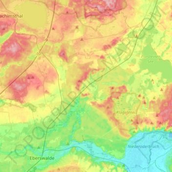
Name: Chorin topographic map, elevation, terrain.

Location: Chorin, Britz-Chorin-Oderberg, Barnim, Brandenburg, Germany (52.84611 13.74332 52.96747 14.02713)

Average elevation: 55 m

Minimum elevation: -2 m

Maximum elevation: 125 m

Gear up for your next adventure:

🥾Hiking Shoes - Durable and comfortable shoes for trail hiking
💧Hydration Bladder - Hands-free hydration solution for long treks
🔥Camping Stove - Portable stoves to cook outdoors with ease
Camping Groundsheet - Protect your tent from moisture and dirt
🪜Heavy Duty Carabiners - Multi-use clips for securing gear to your backpack

As an Amazon Associate, this site earns from qualifying purchases at no extra cost to you.