Geolocate

Sundaram Shozhapuram topographic map

Click on the map to display elevation.

About this map
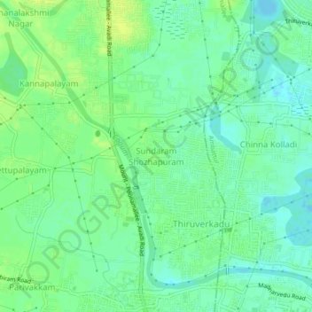
Name: Sundaram Shozhapuram topographic map, elevation, terrain.

Location: Sundaram Shozhapuram, Poonamallee, Thiruvallur, Tamil Nadu, 600077, India (13.06143 80.09452 13.10143 80.13452)

Average elevation: 20 m

Minimum elevation: 12 m

Maximum elevation: 27 m

Other topographic maps

Click on a map to view its topography, its elevation and its terrain.
Cooum

India > Tamil Nadu > Poonamallee

Average elevation: 27 m

Gear up for your next adventure:

🧢Outdoor Cap - Protective cap for sun and rain during hikes
🧊Insulated Water Bottle - Keeps drinks cold in summer and prevents freezing in winter
🛶Waterproof Dry Bags - Keep electronics and clothes dry during river crossings
🪑Insulated Seat Pad - Protect your seat from cold rocks and wet logs
⛺Family Camping Tent - Spacious tent suitable for family camping trips

As an Amazon Associate, this site earns from qualifying purchases at no extra cost to you.