
Make a donation
Gear up for your next adventure:
As an Amazon Associate, this site earns from qualifying purchases at no extra cost to you.
Union Grove topographic map
Click on the map to display elevation.
Make a donation
Gear up for your next adventure:
As an Amazon Associate, this site earns from qualifying purchases at no extra cost to you.
Union Grove
Union Grove is located in western Marshall County at 34°24′0″N 86°26′46″W / 34.40000°N 86.44611°W / 34.40000; -86.44611 (34.400088, -86.446049). It is 7 miles (11 km) northeast of Arab and 5 miles (8 km) southwest of Guntersville Dam on the Tennessee River. Union Grove sits at an elevation of 1,040 feet (320 m) above sea level on the relatively flat top of Brindley Mountain, near the southwest end of the Appalachian Plateau. Electricity service in Union Grove is provided through Arab Electric Cooperative, which comes through the Tennessee Valley Authority.
Make a donation
Gear up for your next adventure:
As an Amazon Associate, this site earns from qualifying purchases at no extra cost to you.
About this map
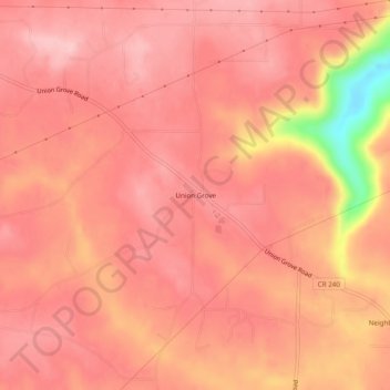
Name: Union Grove topographic map, elevation, terrain.
Location: Union Grove, Marshall County, Alabama, United States (34.38176 -86.46915 34.42176 -86.42915)
Average elevation: 300 m
Minimum elevation: 170 m
Maximum elevation: 335 m
Make a donation
Gear up for your next adventure:
As an Amazon Associate, this site earns from qualifying purchases at no extra cost to you.