Geolocate

Bierbeek topographic map

Click on the map to display elevation.

About this map
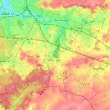
Name: Bierbeek topographic map, elevation, terrain.

Location: Bierbeek, Leuven, Flemish Brabant, Flanders, 3360, Belgium (50.78814 4.69123 50.87564 4.81944)

Average elevation: 71 m

Minimum elevation: 20 m

Maximum elevation: 110 m

Other topographic maps

Click on a map to view its topography, its elevation and its terrain.
Leuven

Belgium > Flemish Brabant > Leuven > Leuven

Average elevation: 50 m

Bos

Belgium > Flemish Brabant > Leuven > Zoutleeuw

Average elevation: 31 m

Orsmaal

Belgium > Flemish Brabant > Leuven

Average elevation: 44 m

Optielt

Belgium > Flemish Brabant > Leuven > Tielt

Average elevation: 51 m

Butsel

Belgium > Flemish Brabant > Leuven > Boutersem

Average elevation: 66 m

Beneden-Kessel

Belgium > Flemish Brabant > Leuven > Leuven > Kessel-Lo

Average elevation: 34 m

Ourodenberg

Belgium > Flemish Brabant > Leuven > Aarschot

Average elevation: 16 m

Stadspark

Belgium > Flemish Brabant > Leuven > Aarschot

Average elevation: 24 m

Gear up for your next adventure:

🧥Waterproof Pants - Keep dry during rainy hiking conditions
🧴Outdoor Sunscreen - High SPF protection for high-altitude UV exposure
🥾Approach Shoes - Shoes designed for climbing approaches and rugged trails
🚲Heavy Duty Bike Lock - Secure your bike at the trailhead or during stops
🥫Freeze-Dried Meals - Lightweight, high-calorie nutrition for multi-day treks

As an Amazon Associate, this site earns from qualifying purchases at no extra cost to you.