Geolocate

Teras topographic map

Click on the map to display elevation.

About this map

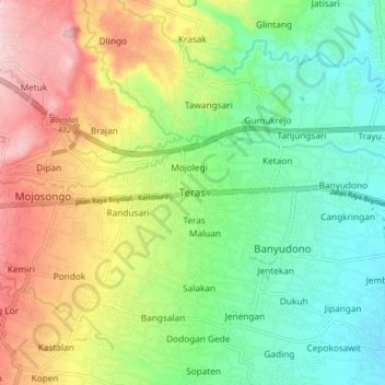
Name: Teras topographic map, elevation, terrain.

Location: Teras, Boyolali, Central Java, Java, 57372, Indonesia (-7.57563 110.61982 -7.49563 110.69982)

Average elevation: 230 m

Minimum elevation: 140 m

Maximum elevation: 367 m

Other topographic maps

Click on a map to view its topography, its elevation and its terrain.

Kecamatan Ngemplak

Indonesia > Central Java > Boyolali

Average elevation: 126 m

Selo

Indonesia > Central Java > Boyolali

Average elevation: 1,442 m

Lencoh

Indonesia > Central Java > Boyolali

Average elevation: 1,672 m

Klakah

Indonesia > Central Java > Boyolali

Average elevation: 1,237 m

Jrakah

Indonesia > Central Java > Boyolali

Average elevation: 1,569 m

Cepogo

Indonesia > Central Java > Boyolali

Average elevation: 1,308 m

Musuk

Indonesia > Central Java > Boyolali

Average elevation: 718 m

Gear up for your next adventure:

💡LED Camping Lantern - Illuminate your campsite with long-lasting lanterns
🥾Durable Hiking Shoes - Long-lasting shoes for frequent hiking
🥾Approach Shoes - Shoes designed for climbing approaches and rugged trails
👟Sport Hiking Sandals - Breathable footwear for water crossings and camp rest
🛶Waterproof Dry Bags - Keep electronics and clothes dry during river crossings

As an Amazon Associate, this site earns from qualifying purchases at no extra cost to you.