Geolocate

St. Austell topographic map

Click on the map to display elevation.

About this map

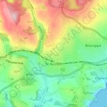
Name: St. Austell topographic map, elevation, terrain.

Location: St. Austell, Cornwall, England, United Kingdom (50.32947 -4.81398 50.35535 -4.74967)

Average elevation: 104 m

Minimum elevation: 0 m

Maximum elevation: 262 m

Other topographic maps

Click on a map to view its topography, its elevation and its terrain.

Trembraze

United Kingdom > England > Cornwall > Liskeard

Average elevation: 128 m

Freathy

United Kingdom > England > Cornwall

Average elevation: 37 m

Riviere Towans

United Kingdom > England > Cornwall > Hayle > Phillack

Average elevation: 19 m

Pinnacle Gully

United Kingdom > England > Cornwall > Porthgwarra

Average elevation: 19 m

Gear up for your next adventure:

🥾All-Terrain Hiking Boots - Versatile boots for varied hiking conditions
Camping Groundsheet - Protect your tent from moisture and dirt
🥤Collapsible Travel Cup - Saves space and weight in your mess kit
🚲Handlebar Phone Mount - View topographic-map.com live while cycling
🥾Hiking Shorts - Breathable shorts suitable for summer hikes

As an Amazon Associate, this site earns from qualifying purchases at no extra cost to you.