
Saint-Luc topographic map
Interactive map
Click on the map to display elevation.
About this map
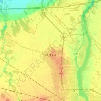
Name: Saint-Luc topographic map, elevation, terrain.
Average elevation: 34 m
Minimum elevation: 12 m
Maximum elevation: 49 m
Other topographic maps
Click on a map to view its topography, its elevation and its terrain.
Saint-Jean-sur-Richelieu
Canada > Québec > Saint-Jean-sur-Richelieu
Saint-Jean-sur-Richelieu, Le Haut-Richelieu, Montérégie, Québec, J3B 2J6, Canada
Average elevation: 41 m