
Make a donation
Gear up for your next adventure:
As an Amazon Associate, this site earns from qualifying purchases at no extra cost to you.
Lee topographic map
Click on the map to display elevation.
Make a donation
Gear up for your next adventure:
As an Amazon Associate, this site earns from qualifying purchases at no extra cost to you.
About this map
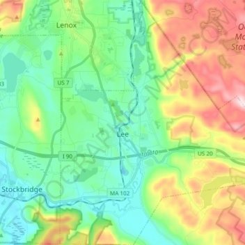
Name: Lee topographic map, elevation, terrain.
Location: Lee, Berkshire County, Massachusetts, 01260, United States (42.25706 -73.28919 42.36807 -73.15994)
Average elevation: 409 m
Minimum elevation: 240 m
Maximum elevation: 683 m
Make a donation
Gear up for your next adventure:
As an Amazon Associate, this site earns from qualifying purchases at no extra cost to you.
Other topographic maps
Click on a map to view its topography, its elevation and its terrain.
Tyringham Cobble
United States > Massachusetts > Berkshire County > Tyringham
Average elevation: 348 m
Indian Lake Association
United States > Massachusetts > Berkshire County > Becket
Average elevation: 455 m
Make a donation
Gear up for your next adventure:
As an Amazon Associate, this site earns from qualifying purchases at no extra cost to you.
West New Boston
United States > Massachusetts > Berkshire County > Sandisfield
Average elevation: 356 m
Make a donation
Gear up for your next adventure:
As an Amazon Associate, this site earns from qualifying purchases at no extra cost to you.
Taconic Mountain Wildlife Management Area
United States > Massachusetts > Berkshire County > Williamstown
Average elevation: 608 m
Make a donation
Gear up for your next adventure:
As an Amazon Associate, this site earns from qualifying purchases at no extra cost to you.
Lake Averic
United States > Massachusetts > Berkshire County > Stockbridge > Interlaken
Average elevation: 326 m
Natural Bridge State Park
United States > Massachusetts > Berkshire County > North Adams
Average elevation: 318 m
Root Orchards
United States > Massachusetts > Berkshire County > Great Barrington > Housatonic > Risingdale
Average elevation: 278 m
Make a donation
Gear up for your next adventure:
As an Amazon Associate, this site earns from qualifying purchases at no extra cost to you.
Berkshire South
United States > Massachusetts > Berkshire County > Great Barrington
Average elevation: 266 m
Make a donation
Gear up for your next adventure:
As an Amazon Associate, this site earns from qualifying purchases at no extra cost to you.
North Adams
United States > Massachusetts > Berkshire County > North Adams > North Adams
Average elevation: 415 m
Beachwood
United States > Massachusetts > Berkshire County > Stockbridge > Beachwood
Average elevation: 317 m
Make a donation
Gear up for your next adventure:
As an Amazon Associate, this site earns from qualifying purchases at no extra cost to you.