Geolocate

Lake Tekapo topographic map

Click on the map to display elevation.

About this map

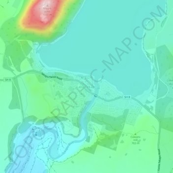
Name: Lake Tekapo topographic map, elevation, terrain.

Location: Lake Tekapo, Mackenzie District, Canterbury, New Zealand (-44.02452 170.45773 -43.98452 170.49773)

Average elevation: 743 m

Minimum elevation: 672 m

Maximum elevation: 1,030 m

Other topographic maps

Click on a map to view its topography, its elevation and its terrain.

Gear up for your next adventure:

🔪Outdoor Multitool - Versatile tool for repairs and food prep in the wild
🕯️Camping Lantern - Illuminates your entire campsite with high-efficiency LEDs
💡Compact LED Flashlight - Powerful and portable flashlight for outdoor use
🛰️Satellite Messenger - Emergency communication for areas with no cell service
🥾Waterproof Hiking Boots - Essential footwear for rugged terrain and wet Canadian trails

As an Amazon Associate, this site earns from qualifying purchases at no extra cost to you.