
Make a donation
Gear up for your next adventure:
As an Amazon Associate, this site earns from qualifying purchases at no extra cost to you.
La Maliciosa topographic map
Click on the map to display elevation.
Make a donation
Gear up for your next adventure:
As an Amazon Associate, this site earns from qualifying purchases at no extra cost to you.
La Maliciosa
La Maliciosa is one of the most important and highest mountains of the Sierra de Guadarrama, a mountainous formation belonging to the Sistema Central. It has an altitude of 2227m above sea level and is located in the northwest of the Community of Madrid, in Spain, rising between La Pedriza, which lies to the east, and La Barranca valley, which is on its western slope.
Make a donation
Gear up for your next adventure:
As an Amazon Associate, this site earns from qualifying purchases at no extra cost to you.
About this map
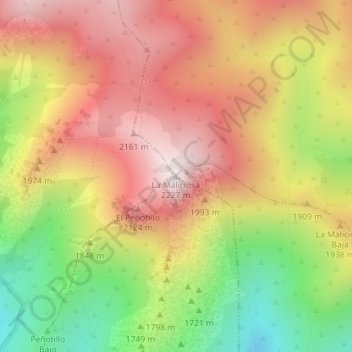
Name: La Maliciosa topographic map, elevation, terrain.
Location: La Maliciosa, Navacerrada, Community of Madrid, 28492, Spain (40.76708 -3.96867 40.76718 -3.96857)
Average elevation: 1,856 m
Minimum elevation: 1,420 m
Maximum elevation: 2,210 m
Make a donation
Gear up for your next adventure:
As an Amazon Associate, this site earns from qualifying purchases at no extra cost to you.