Geolocate

Kawayan topographic map

Click on the map to display elevation.

About this map

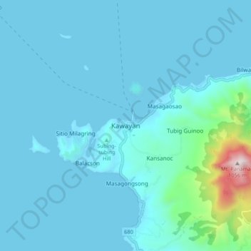
Name: Kawayan topographic map, elevation, terrain.

Location: Kawayan, Biliran, Eastern Visayas, 6545, Philippines (11.63995 124.31702 11.71995 124.39702)

Average elevation: 88 m

Minimum elevation: -1 m

Maximum elevation: 1,052 m

Other topographic maps

Click on a map to view its topography, its elevation and its terrain.

Maripipi

Philippines > Biliran

Average elevation: 52 m

Biliran

Philippines > Biliran

Average elevation: 170 m

Anas River

Philippines > Biliran > Larrazabal

Average elevation: 200 m

Sambawan Islands

Philippines > Biliran > Maripipi

Average elevation: 0 m

Biliran

Philippines > Biliran

Average elevation: 170 m

Gear up for your next adventure:

Camping Coffee Maker - Brew fresh coffee anywhere on the topographic map
🧰Multitool Knife - Compact and versatile tool for outdoor use
🕶️Polarized Sunglasses - Protect your eyes with durable polarized lenses
🥾Trail Hiking Boots - Supportive boots for rough trails
🔭Outdoor Binoculars - Lightweight binoculars for birdwatching and hiking

As an Amazon Associate, this site earns from qualifying purchases at no extra cost to you.