Geolocate

Reggio Calabria topographic map

Click on the map to display elevation.

About this map
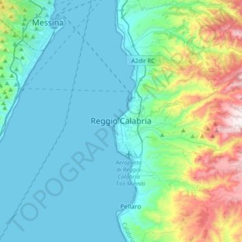
Name: Reggio Calabria topographic map, elevation, terrain.

Location: Reggio Calabria, Calabria, Italy (37.99182 15.63023 38.21412 15.86504)

Average elevation: 224 m

Minimum elevation: 0 m

Maximum elevation: 1,187 m

Other topographic maps

Click on a map to view its topography, its elevation and its terrain.
Saline Joniche

Italy > Calabria > Reggio Calabria

Average elevation: 58 m

Gambarie

Italy > Calabria > Reggio Calabria

Average elevation: 1,305 m

Monasterace Marina

Italy > Calabria > Reggio Calabria

Average elevation: 19 m

Gear up for your next adventure:

🧦Hiking Socks - Moisture-wicking and comfortable socks for long hikes
💧Hydration Pack - Hands-free hydration system for long hikes
🦶Hiking Shoe Insoles - Added support for high arches and long days on feet
🔋Lithium AA Batteries - Long-lasting power that performs in extreme cold
🏕️Camping Hammock - Integrated protection for sleeping between trees

As an Amazon Associate, this site earns from qualifying purchases at no extra cost to you.