
Make a donation
Gear up for your next adventure:
As an Amazon Associate, this site earns from qualifying purchases at no extra cost to you.
Lez topographic map
Click on the map to display elevation.
Make a donation
Gear up for your next adventure:
As an Amazon Associate, this site earns from qualifying purchases at no extra cost to you.
Lez
La superficie de la commune est de 260 hectares. Son altitude minimale, 499 mètres, se situe là où la Garonne quitte la commune pour entrer sur celle de Saint-Béat. L'altitude maximale, 1 180 (ou 1 181) mètres, est atteinte au sud-est, au Rocher du Midi, en limite d'Argut-Dessus, commune associée à Boutx.
Make a donation
Gear up for your next adventure:
As an Amazon Associate, this site earns from qualifying purchases at no extra cost to you.
About this map
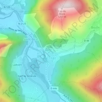
Name: Lez topographic map, elevation, terrain.
Average elevation: 720 m
Minimum elevation: 488 m
Maximum elevation: 1,250 m
Make a donation
Gear up for your next adventure:
As an Amazon Associate, this site earns from qualifying purchases at no extra cost to you.
Other topographic maps
Click on a map to view its topography, its elevation and its terrain.
Make a donation
Gear up for your next adventure:
As an Amazon Associate, this site earns from qualifying purchases at no extra cost to you.