Geolocate

Palomar topographic map

Click on the map to display elevation.

About this map

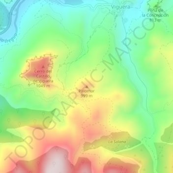
Name: Palomar topographic map, elevation, terrain.

Location: Palomar, Viguera, La Rioja, 26121, España (42.29569 -2.54100 42.29579 -2.54090)

Average elevation: 836 m

Minimum elevation: 616 m

Maximum elevation: 1,149 m

Gear up for your next adventure:

🧥Softshell Jacket - Windproof and breathable jacket for hiking
🚲Handlebar Phone Mount - View topographic-map.com live while cycling
🔦LED Headlamp - Hands-free lighting for early morning starts or late finishes
🧴Insect Repellent - Protect yourself from bugs during outdoor adventures
Camping Essentials - All-in-one gear for a comfortable camping trip

As an Amazon Associate, this site earns from qualifying purchases at no extra cost to you.