Geolocate

Fairlawn topographic map

Click on the map to display elevation.

About this map

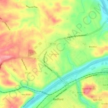
Name: Fairlawn topographic map, elevation, terrain.

Location: Fairlawn, Pulaski County, Virginia, 24129, United States (37.12846 -80.59839 37.16846 -80.55839)

Average elevation: 571 m

Minimum elevation: 514 m

Maximum elevation: 625 m

Other topographic maps

Click on a map to view its topography, its elevation and its terrain.

Pulaski

United States > Virginia > Pulaski County

Average elevation: 650 m

Hogan Lake

United States > Virginia > Pulaski County

Average elevation: 721 m

Parrott

United States > Virginia > Pulaski County

Average elevation: 604 m

Gear up for your next adventure:

🧴Waterproofing Spray - Restore the DWR coating on jackets and tents
🧴Outdoor Sunscreen - High SPF protection for high-altitude UV exposure
🧳Compression Sacks - Maximize space in your backpack by shrinking gear
🔦UV Flashlight - Detect minerals or specific insects in the dark
🛶Waterproof Dry Bags - Keep electronics and clothes dry during river crossings

As an Amazon Associate, this site earns from qualifying purchases at no extra cost to you.