
Thank you for supporting this site ❤️
Make a donation
Make a donation
Gear up for your next adventure:
As an Amazon Associate, this site earns from qualifying purchases at no extra cost to you.
Taşbaşı topographic map
Click on the map to display elevation.
Thank you for supporting this site ❤️
Make a donation
Make a donation
Gear up for your next adventure:
As an Amazon Associate, this site earns from qualifying purchases at no extra cost to you.
About this map
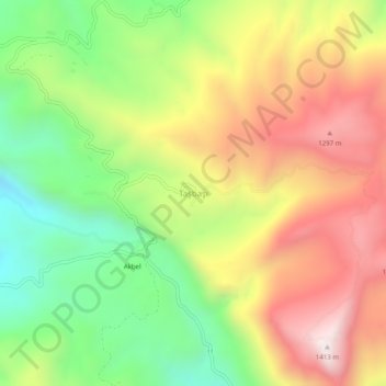
Name: Taşbaşı topographic map, elevation, terrain.
Location: Taşbaşı, Dalaman, Muğla, Aegean Region, Turkey (36.86507 28.99214 36.90507 29.03214)
Average elevation: 938 m
Minimum elevation: 490 m
Maximum elevation: 1,426 m
Thank you for supporting this site ❤️
Make a donation
Make a donation
Gear up for your next adventure:
As an Amazon Associate, this site earns from qualifying purchases at no extra cost to you.