
Make a donation
Gear up for your next adventure:
As an Amazon Associate, this site earns from qualifying purchases at no extra cost to you.
Jbel Ayachi topographic map
Click on the map to display elevation.
Make a donation
Gear up for your next adventure:
As an Amazon Associate, this site earns from qualifying purchases at no extra cost to you.
Jbel Ayachi
Le djebel Ayachi (en arabe : جبل العياشي Jbel Ayachi ; en tamazight ⴰⴷⵔⴰⵔ ⵏ ⵄⴰⵢⵢⴰⵛ Adrar n Ayyach) est un sommet du Haut Atlas, au Maroc, culminant à 3 757 m d'altitude. Situé au sud-ouest de Midelt, il abrite des gypaètes barbus.
Make a donation
Gear up for your next adventure:
As an Amazon Associate, this site earns from qualifying purchases at no extra cost to you.
About this map
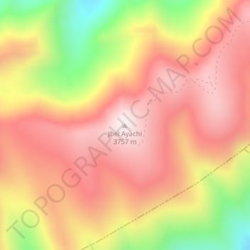
Name: Jbel Ayachi topographic map, elevation, terrain.
Average elevation: 3,456 m
Minimum elevation: 3,012 m
Maximum elevation: 3,730 m
Make a donation
Gear up for your next adventure:
As an Amazon Associate, this site earns from qualifying purchases at no extra cost to you.