Geolocate

Shade topographic map

Click on the map to display elevation.

About this map

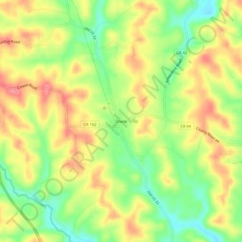
Name: Shade topographic map, elevation, terrain.

Location: Shade, Lodi Township, Athens County, Ohio, United States (39.20591 -82.05848 39.24591 -82.01848)

Average elevation: 258 m

Minimum elevation: 214 m

Maximum elevation: 298 m

Other topographic maps

Click on a map to view its topography, its elevation and its terrain.

Nelsonville

United States > Ohio > Athens County

Average elevation: 247 m

Glouster

United States > Ohio > Athens County

Average elevation: 235 m

Lodi Township

United States > Ohio > Athens County

Average elevation: 255 m

Alexander Township

United States > Ohio > Athens County

Average elevation: 250 m

Albany

United States > Ohio > Athens County

Average elevation: 235 m

Amesville

United States > Ohio > Athens County

Amesville is situated in the foothills of the Appalachian Mountains, approximately 45 miles south by southeast of the terminal moraine, a topographical feature often associated with the boundaries of glaciers, and is surrounded by wooded hills, narrow valleys, and numerous creeks flanked by lowland pastures…

Average elevation: 223 m

Gear up for your next adventure:

🧴Outdoor Sunscreen - High SPF protection for high-altitude UV exposure
🥫Freeze-Dried Meals - Lightweight, high-calorie nutrition for multi-day treks
🦯Trekking Poles - Reduced impact on joints for steep topographic climbs
🥾Mountaineering Boots - Supportive boots for climbing and high-altitude hiking
🧶550 Survival Paracord - Versatile utility cord for emergency repairs and rigging

As an Amazon Associate, this site earns from qualifying purchases at no extra cost to you.