
Thank you for supporting this site ❤️
Make a donation
Make a donation
Gear up for your next adventure:
As an Amazon Associate, this site earns from qualifying purchases at no extra cost to you.
Ploçë topographic map
Click on the map to display elevation.
Thank you for supporting this site ❤️
Make a donation
Make a donation
Gear up for your next adventure:
As an Amazon Associate, this site earns from qualifying purchases at no extra cost to you.
About this map
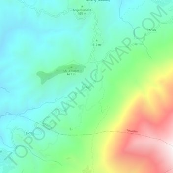
Name: Ploçë topographic map, elevation, terrain.
Location: Ploçë, Sevaster, Bashkia Selenicë, Vlorë County, 9410, Albania (40.35555 19.68802 40.39555 19.72802)
Average elevation: 610 m
Minimum elevation: 206 m
Maximum elevation: 1,621 m
Thank you for supporting this site ❤️
Make a donation
Make a donation
Gear up for your next adventure:
As an Amazon Associate, this site earns from qualifying purchases at no extra cost to you.