Geolocate

Castelfidardo topographic map

Click on the map to display elevation.

About this map
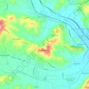
Name: Castelfidardo topographic map, elevation, terrain.

Location: Castelfidardo, Ancona, Marche, 60022, Italy (43.43932 13.51093 43.50067 13.62425)

Average elevation: 52 m

Minimum elevation: 2 m

Maximum elevation: 229 m

Gear up for your next adventure:

🧢Sun Hat - Wide-brim hat for sun protection
🍽️Titanium Camping Spork - Ultralight and indestructible eating utensil
🧢Outdoor Visor - Breathable visor for sunny hikes
🧦Thermal Socks - Warm socks for winter hiking or camping
🔦LED Flashlight - Powerful and long-lasting flashlight for camping and emergencies

As an Amazon Associate, this site earns from qualifying purchases at no extra cost to you.