
Make a donation
Gear up for your next adventure:
As an Amazon Associate, this site earns from qualifying purchases at no extra cost to you.
Lago Ranco topographic map
Click on the map to display elevation.
Make a donation
Gear up for your next adventure:
As an Amazon Associate, this site earns from qualifying purchases at no extra cost to you.
About this map
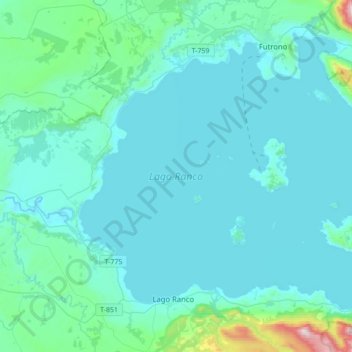
Name: Lago Ranco topographic map, elevation, terrain.
Location: Lago Ranco, Provincia de Ranco, Región de Los Ríos, Chile (-40.33711 -72.57426 -40.12041 -72.22681)
Average elevation: 159 m
Minimum elevation: 51 m
Maximum elevation: 1,263 m
Make a donation
Gear up for your next adventure:
As an Amazon Associate, this site earns from qualifying purchases at no extra cost to you.
Other topographic maps
Click on a map to view its topography, its elevation and its terrain.
Santa Laura
Chile > Región de Los Ríos > Provincia de Ranco > Futrono > Nontuela
Average elevation: 263 m
Make a donation
Gear up for your next adventure:
As an Amazon Associate, this site earns from qualifying purchases at no extra cost to you.
Puerto Nuevo Alto
Chile > Región de Los Ríos > Provincia de Ranco > Comuna de La Unión
Average elevation: 95 m