
Make a donation
Gear up for your next adventure:
As an Amazon Associate, this site earns from qualifying purchases at no extra cost to you.
Bayog topographic map
Click on the map to display elevation.
Make a donation
Gear up for your next adventure:
As an Amazon Associate, this site earns from qualifying purchases at no extra cost to you.
Bayog
The town is partly situated in the Sibougey Valley watered by the Sibuguey River, Dipili River, and Depore River. 75% of the land lies on rugged terrain with elevation up to 300 metres (980 ft).
Make a donation
Gear up for your next adventure:
As an Amazon Associate, this site earns from qualifying purchases at no extra cost to you.
About this map
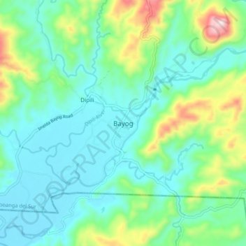
Name: Bayog topographic map, elevation, terrain.
Average elevation: 137 m
Minimum elevation: 26 m
Maximum elevation: 485 m
Make a donation
Gear up for your next adventure:
As an Amazon Associate, this site earns from qualifying purchases at no extra cost to you.
Other topographic maps
Click on a map to view its topography, its elevation and its terrain.