
Make a donation
Gear up for your next adventure:
As an Amazon Associate, this site earns from qualifying purchases at no extra cost to you.
Judenbach topographic map
Click on the map to display elevation.
Make a donation
Gear up for your next adventure:
As an Amazon Associate, this site earns from qualifying purchases at no extra cost to you.
Judenbach
Das Klima Judenbachs ist durch seine Höhenlage gekennzeichnet. Zusätzlich wird es durch die Hauptwindrichtung aus West bzw. Südwest beeinflusst. Die Sommer sind verhältnismäßig warm, milde Winter verhindert dagegen die Nähe zum Thüringer Wald.
Make a donation
Gear up for your next adventure:
As an Amazon Associate, this site earns from qualifying purchases at no extra cost to you.
About this map
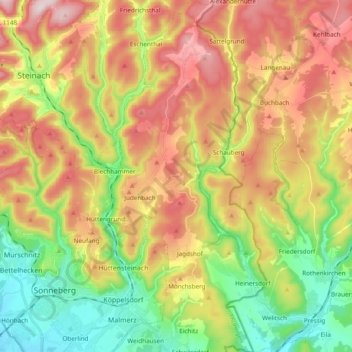
Name: Judenbach topographic map, elevation, terrain.
Average elevation: 558 m
Minimum elevation: 338 m
Maximum elevation: 838 m
Make a donation
Gear up for your next adventure:
As an Amazon Associate, this site earns from qualifying purchases at no extra cost to you.
Other topographic maps
Click on a map to view its topography, its elevation and its terrain.