Make a donation
Gear up for your next adventure:
As an Amazon Associate, this site earns from qualifying purchases at no extra cost to you.
Sibulan topographic map
Click on the map to display elevation.
Make a donation
Gear up for your next adventure:
As an Amazon Associate, this site earns from qualifying purchases at no extra cost to you.
About this map
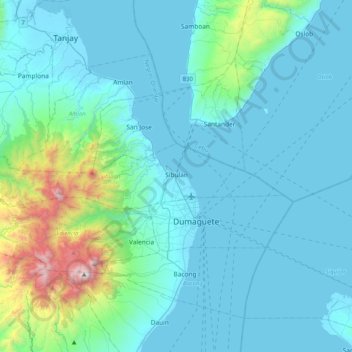
Name: Sibulan topographic map, elevation, terrain.
Location: Sibulan, Negros Oriental, Central Visayas, 6201, Philippines (9.31935 123.00174 9.39503 123.41008)
Average elevation: 217 m
Minimum elevation: 0 m
Maximum elevation: 1,822 m
Make a donation
Gear up for your next adventure:
As an Amazon Associate, this site earns from qualifying purchases at no extra cost to you.
Other topographic maps
Click on a map to view its topography, its elevation and its terrain.
Make a donation
Gear up for your next adventure:
As an Amazon Associate, this site earns from qualifying purchases at no extra cost to you.
Make a donation
Gear up for your next adventure:
As an Amazon Associate, this site earns from qualifying purchases at no extra cost to you.
Make a donation
Gear up for your next adventure:
As an Amazon Associate, this site earns from qualifying purchases at no extra cost to you.
Pamplona
Mountain ridges overlooking the plains of Pamplona, can be an object for viewers of scenic beauties. Nabalabag ridge, located at an elevation of 800 m above sea level at barangay San Isidro, overlooks on the west at municipalities of Bayawan and Santa Catalina and in the east, with the town of Pamplona, Tanjay…
Average elevation: 61 m
Make a donation
Gear up for your next adventure:
As an Amazon Associate, this site earns from qualifying purchases at no extra cost to you.
