Geolocate

Rösrath topographic map

Click on the map to display elevation.

About this map

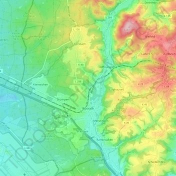
Name: Rösrath topographic map, elevation, terrain.

Location: Rösrath, Rheinisch-Bergischer Kreis, North Rhine-Westphalia, 51503, Germany (50.86703 7.13353 50.94310 7.24725)

Average elevation: 123 m

Minimum elevation: 52 m

Maximum elevation: 258 m

Other topographic maps

Click on a map to view its topography, its elevation and its terrain.

Gear up for your next adventure:

🥾Waterproof Hiking Boots - Boots keeping your feet dry in wet conditions
🔦LED Flashlight - Powerful and long-lasting flashlight for camping and emergencies
🗺️Topographic Maps - Detailed maps to explore trails, mountains, and wilderness areas
🧥Thermal Layer - Insulating layer for cold outdoor conditions
🧴Bear Spray Holster - Quick-access carry for essential Canadian wilderness safety

As an Amazon Associate, this site earns from qualifying purchases at no extra cost to you.