Geolocate

Pichilemu topographic map

Click on the map to display elevation.

Pichilemu

Pichilemu is located 126 kilometres (78 mi) west of San Fernando, in the westernmost area of the O'Higgins Region, on the coast of the Pacific Ocean. It is within a three-hour drive of the Andes Mountains. It is near the Cordillera de la Costa (Coastal Mountain Range) which rises to 2,000 metres (6,562 ft) in elevation.

Wikipedia (CC-BY-SA 3.0)

About this map

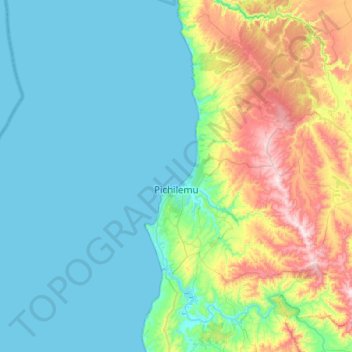
Name: Pichilemu topographic map, elevation, terrain.

Location: Pichilemu, Provincia de Cardenal Caro, O'Higgins Region, Chile (-34.57614 -72.05176 -34.16251 -71.74661)

Average elevation: 127 m

Minimum elevation: 0 m

Maximum elevation: 602 m

Other topographic maps

Click on a map to view its topography, its elevation and its terrain.

Gear up for your next adventure:

🧦Hiking Liner Socks - Thin base layer to prevent friction and blisters
🪑Ultralight Camping Stool - Compact seating for rest stops during long hikes
🧶550 Survival Paracord - Versatile utility cord for emergency repairs and rigging
🥾All-Terrain Hiking Boots - Versatile boots for varied hiking conditions
🥤Collapsible Travel Cup - Saves space and weight in your mess kit

As an Amazon Associate, this site earns from qualifying purchases at no extra cost to you.