
Make a donation
Gear up for your next adventure:
As an Amazon Associate, this site earns from qualifying purchases at no extra cost to you.
Brooks topographic map
Click on the map to display elevation.
Make a donation
Gear up for your next adventure:
As an Amazon Associate, this site earns from qualifying purchases at no extra cost to you.
Brooks
Brooks is a city in southeast Alberta, Canada in the County of Newell. It is on Highway 1 (Trans-Canada Highway) and the Canadian Pacific Kansas City railway, approximately 186 km (116 mi) southeast of Calgary, and 110 km (68 mi) northwest of Medicine Hat. The city has an elevation of 760 m (2,490 ft).
Make a donation
Gear up for your next adventure:
As an Amazon Associate, this site earns from qualifying purchases at no extra cost to you.
About this map
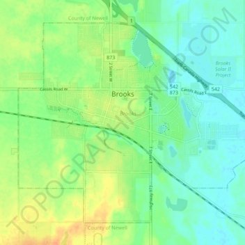
Name: Brooks topographic map, elevation, terrain.
Location: Brooks, City of Brooks, Alberta, Canada (50.54286 -111.92915 50.58660 -111.84309)
Average elevation: 758 m
Minimum elevation: 745 m
Maximum elevation: 777 m
City of Brooks trails, hiking, mountain biking, running and outdoor activities
Make a donation
Gear up for your next adventure:
As an Amazon Associate, this site earns from qualifying purchases at no extra cost to you.