Geolocate

Resguardo topographic map

Click on the map to display elevation.

About this map

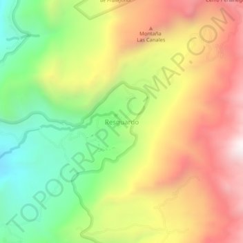
Name: Resguardo topographic map, elevation, terrain.

Location: Resguardo, Socotá, Valderrama, Boyacá, 151620, Colombia (6.01601 -72.62590 6.05601 -72.58590)

Average elevation: 3,167 m

Minimum elevation: 2,570 m

Maximum elevation: 3,808 m

Gear up for your next adventure:

🥘Camping Cookware Set - Compact nesting pots and pans for trail cooking
🥾Waterproof Hiking Boots - Essential footwear for rugged terrain and wet Canadian trails
🛶Kayak Accessories - Essential gear for safe and fun kayaking adventures
🔋Solar Power Bank - Keep your GPS and devices charged during long outdoor trips
🧼Biodegradable Camp Soap - Environmentally friendly cleaning for gear and body

As an Amazon Associate, this site earns from qualifying purchases at no extra cost to you.