
Make a donation
Gear up for your next adventure:
As an Amazon Associate, this site earns from qualifying purchases at no extra cost to you.
Gauselfingen topographic map
Click on the map to display elevation.
Make a donation
Gear up for your next adventure:
As an Amazon Associate, this site earns from qualifying purchases at no extra cost to you.
About this map
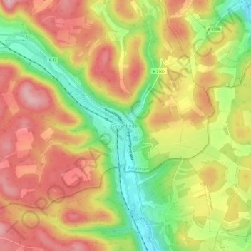
Name: Gauselfingen topographic map, elevation, terrain.
Average elevation: 780 m
Minimum elevation: 679 m
Maximum elevation: 861 m
Make a donation
Gear up for your next adventure:
As an Amazon Associate, this site earns from qualifying purchases at no extra cost to you.
Other topographic maps
Click on a map to view its topography, its elevation and its terrain.
Stetten unter Holstein
Deutschland > Baden-Württemberg > Zollernalbkreis > Burladingen
Average elevation: 776 m
Make a donation
Gear up for your next adventure:
As an Amazon Associate, this site earns from qualifying purchases at no extra cost to you.
72393
Deutschland > Baden-Württemberg > Zollernalbkreis > Burladingen > Ringingen
Average elevation: 785 m
Hausen im Killertal
Deutschland > Baden-Württemberg > Zollernalbkreis > Burladingen
Average elevation: 820 m