Geolocate

Amsterdam topographic map

Click on the map to display elevation.

About this map

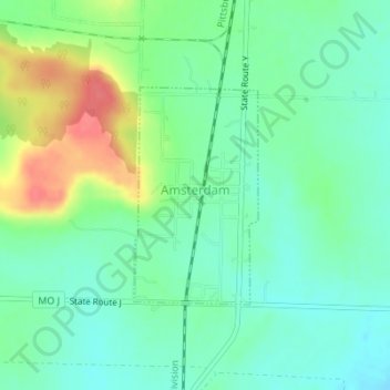
Name: Amsterdam topographic map, elevation, terrain.

Location: Amsterdam, Bates County, Missouri, United States (38.34178 -94.59460 38.35683 -94.58358)

Average elevation: 273 m

Minimum elevation: 252 m

Maximum elevation: 317 m

Other topographic maps

Click on a map to view its topography, its elevation and its terrain.

Altona

United States > Missouri > Bates County

Average elevation: 260 m

Butler City Dam

United States > Missouri > Bates County

Average elevation: 246 m

Virginia

United States > Missouri > Bates County

Average elevation: 264 m

Gear up for your next adventure:

🔋Emergency Crank Radio - Weather alerts and power without needing batteries
🧢Sun Hat - Wide-brim hat for sun protection
🧦Thermal Socks - Warm socks for winter hiking or camping
👟Leg Gaiters - Keep debris, mud, and snow out of your boots
🚲Handlebar Phone Mount - View topographic-map.com live while cycling

As an Amazon Associate, this site earns from qualifying purchases at no extra cost to you.