
Make a donation
Gear up for your next adventure:
As an Amazon Associate, this site earns from qualifying purchases at no extra cost to you.
Rauhkopf topographic map
Click on the map to display elevation.
Make a donation
Gear up for your next adventure:
As an Amazon Associate, this site earns from qualifying purchases at no extra cost to you.
Rauhkopf
Der Anstiegsweg führt von der Bonn-Matreier Hütte zunächst auf dem Venediger Höhenweg ostwärts zur Kälberscharte. Von dort geht es in einem steilen Steig in einer erdigen Schuttrinne hinauf auf den Südostrücken und über diesen zunächst unschwierig bis kurz vor den Gipfel. Die letzten Meter zum Gipfel verlangen bei leichter Blockkletterei (Schwierigkeit II- nach UIAA) Trittsicherheit und Schwindelfreiheit. Von der Hütte ist der Gipfel in etwa einer Stunde zu erreichen.
Make a donation
Gear up for your next adventure:
As an Amazon Associate, this site earns from qualifying purchases at no extra cost to you.
About this map
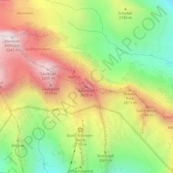
Name: Rauhkopf topographic map, elevation, terrain.
Location: Rauhkopf, Matrei in Osttirol, Bezirk Lienz, Tirol, Österreich (47.04574 12.42892 47.04584 12.42902)
Average elevation: 2,655 m
Minimum elevation: 2,137 m
Maximum elevation: 3,209 m
Make a donation
Gear up for your next adventure:
As an Amazon Associate, this site earns from qualifying purchases at no extra cost to you.
Other topographic maps
Click on a map to view its topography, its elevation and its terrain.