
Thank you for supporting this site ❤️
Make a donation
Make a donation
Gear up for your next adventure:
As an Amazon Associate, this site earns from qualifying purchases at no extra cost to you.
Cortos topographic map
Click on the map to display elevation.
Thank you for supporting this site ❤️
Make a donation
Make a donation
Gear up for your next adventure:
As an Amazon Associate, this site earns from qualifying purchases at no extra cost to you.
About this map
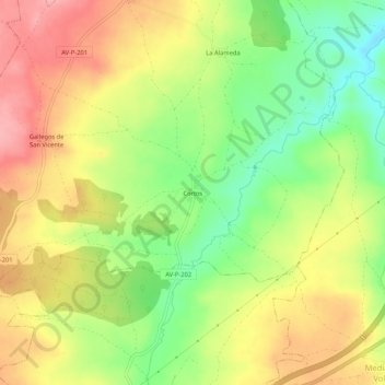
Name: Cortos topographic map, elevation, terrain.
Location: Cortos, Tolbaños, Ávila, Castilië en León, 05289, Spanje (40.69862 -4.60955 40.73862 -4.56955)
Average elevation: 1,104 m
Minimum elevation: 1,043 m
Maximum elevation: 1,162 m
Thank you for supporting this site ❤️
Make a donation
Make a donation
Gear up for your next adventure:
As an Amazon Associate, this site earns from qualifying purchases at no extra cost to you.