
Make a donation
Gear up for your next adventure:
As an Amazon Associate, this site earns from qualifying purchases at no extra cost to you.
Lake Nakuru topographic map
Click on the map to display elevation.
Make a donation
Gear up for your next adventure:
As an Amazon Associate, this site earns from qualifying purchases at no extra cost to you.
Lake Nakuru
Lake Nakuru is one of the Rift Valley soda lakes at an elevation of 1,754 m (5,755 ft) above sea level. It lies to the south of Nakuru, in the rift valley of Kenya and is protected by Lake Nakuru National Park.
Make a donation
Gear up for your next adventure:
As an Amazon Associate, this site earns from qualifying purchases at no extra cost to you.
About this map
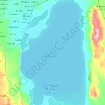
Name: Lake Nakuru topographic map, elevation, terrain.
Location: Lake Nakuru, Kaloleni, Nakuru, Kenya (-0.40762 36.05632 -0.30774 36.11811)
Average elevation: 1,807 m
Minimum elevation: 1,754 m
Maximum elevation: 2,095 m
Make a donation
Gear up for your next adventure:
As an Amazon Associate, this site earns from qualifying purchases at no extra cost to you.