Geolocate

Dona Paula topographic map

Click on the map to display elevation.

About this map

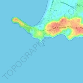
Name: Dona Paula topographic map, elevation, terrain.

Location: Dona Paula, North Goa, Goa, 403 004, India (15.43266 73.78256 15.47266 73.82256)

Average elevation: 5 m

Minimum elevation: 0 m

Maximum elevation: 51 m

Gear up for your next adventure:

🧢Outdoor Visor - Breathable visor for sunny hikes
Family Camping Tent - Spacious tent suitable for family camping trips
🩹Moleskin Blister Pads - Direct protection for painful foot pressure points
🥾Hiking Shorts - Breathable shorts suitable for summer hikes
🧦Hiking Socks - Moisture-wicking and comfortable socks for long hikes

As an Amazon Associate, this site earns from qualifying purchases at no extra cost to you.