Geolocate

Rives Township topographic map

Click on the map to display elevation.

About this map

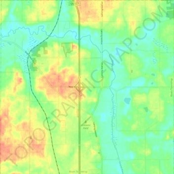
Name: Rives Township topographic map, elevation, terrain.

Location: Rives Township, Jackson County, Michigan, 49277, United States (42.33474 -84.48277 42.42211 -84.36472)

Average elevation: 289 m

Minimum elevation: 270 m

Maximum elevation: 313 m

Other topographic maps

Click on a map to view its topography, its elevation and its terrain.

Liberty

United States > Michigan > Jackson County

Average elevation: 312 m

White Lake

United States > Michigan > Jackson County

Average elevation: 288 m

Sherman Lake

United States > Michigan > Jackson County

Average elevation: 295 m

Gear up for your next adventure:

🏕️Camping Hammock - Integrated protection for sleeping between trees
🦶Anti-Blister Balm - Prevents friction and hotspots during long ascents
🎒Hiking Daypack - Lightweight and durable backpacks for day trips and excursions
🧼Travel Hand Sanitizer - Keep hands clean when water is scarce
🧢Outdoor Cap - Protective cap for sun and rain during hikes

As an Amazon Associate, this site earns from qualifying purchases at no extra cost to you.