
Plymouth topographic map
Interactive map
Click on the map to display elevation.
About this map
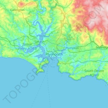
Name: Plymouth topographic map, elevation, terrain.
Location: Plymouth, South West England, Angleterre, PL1 1HH, Royaume-Uni (50.21127 -4.30257 50.53127 -3.98257)
Average elevation: 81 m
Minimum elevation: -3 m
Maximum elevation: 512 m
Other topographic maps
Click on a map to view its topography, its elevation and its terrain.
Dartmoor
Royaume-Uni > Angleterre > Plymouth
Dartmoor, Albion Drive, Ham, Plymouth, South West England, Angleterre, PL2 2QL, Royaume-Uni
Average elevation: 239 m