Geolocate

Barro Negro topographic map

Click on the map to display elevation.

About this map

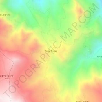
Name: Barro Negro topographic map, elevation, terrain.

Location: Barro Negro, Usquil, Otuzco, La Libertad, Perú (-7.89658 -78.38271 -7.85658 -78.34271)

Average elevation: 3,512 m

Minimum elevation: 2,998 m

Maximum elevation: 3,993 m

Gear up for your next adventure:

🔋Emergency Crank Radio - Weather alerts and power without needing batteries
🧢Sun Hat - Wide-brim hat for sun protection
🧢Beanie Hat - Keep your head warm in cold weather
🧳Compression Sacks - Maximize space in your backpack by shrinking gear
Camping Coffee Maker - Brew fresh coffee anywhere on the topographic map

As an Amazon Associate, this site earns from qualifying purchases at no extra cost to you.