
Banka topographic map
Interactive map
Click on the map to display elevation.
About this map
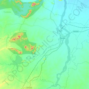
Name: Banka topographic map, elevation, terrain.
Location: Banka, Bihar, India (24.76542 86.77156 24.96676 87.00193)
Average elevation: 112 m
Minimum elevation: 64 m
Maximum elevation: 338 m
Other topographic maps
Click on a map to view its topography, its elevation and its terrain.
Bagmati River
Bagmati River, Sītāmarhi, Sitamarhi, Bihar, 843321, India
Average elevation: 422 m