Geolocate

East Ocean View topographic map

Click on the map to display elevation.

About this map

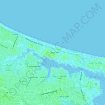
Name: East Ocean View topographic map, elevation, terrain.

Location: East Ocean View, Norfolk, Virginia, 23518, United States (36.91154 -76.22577 36.95154 -76.18577)

Average elevation: 2 m

Minimum elevation: -3 m

Maximum elevation: 10 m

Other topographic maps

Click on a map to view its topography, its elevation and its terrain.

Lake Taylor

United States > Virginia > Norfolk > Lake Terrace

Average elevation: 7 m

Broad Creek

United States > Virginia > Norfolk > River Oaks

Average elevation: 6 m

Gear up for your next adventure:

🧥Fleece Jacket - Warm and lightweight jacket for layering
🧰Multitool Knife - Compact and versatile tool for outdoor use
📷Outdoor Action Camera - Capture high-elevation views and rugged adventures
💧Collapsible Water Bottle - Space-saving water bottle for outdoor activities
🧥Ultralight Puffy Jacket - Maximum warmth that packs down to the size of an orange

As an Amazon Associate, this site earns from qualifying purchases at no extra cost to you.