
Thank you for supporting this site ❤️
Make a donation
Make a donation
Gear up for your next adventure:
As an Amazon Associate, this site earns from qualifying purchases at no extra cost to you.
Kiamunyeki topographic map
Click on the map to display elevation.
Thank you for supporting this site ❤️
Make a donation
Make a donation
Gear up for your next adventure:
As an Amazon Associate, this site earns from qualifying purchases at no extra cost to you.
About this map
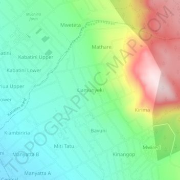
Name: Kiamunyeki topographic map, elevation, terrain.
Location: Kiamunyeki, Dundori ward, Bahati, Nakuru, Kenya (-0.24773 36.15924 -0.20773 36.19924)
Average elevation: 2,104 m
Minimum elevation: 1,953 m
Maximum elevation: 2,417 m
Thank you for supporting this site ❤️
Make a donation
Make a donation
Gear up for your next adventure:
As an Amazon Associate, this site earns from qualifying purchases at no extra cost to you.