Geolocate

Lake Holon topographic map

Click on the map to display elevation.

About this map

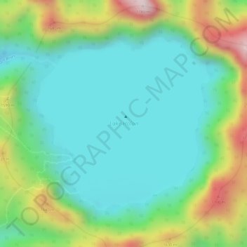
Name: Lake Holon topographic map, elevation, terrain.

Location: Lake Holon, T'Boli, South Cotabato, Soccsksargen, Philippines (6.09134 124.87887 6.11027 124.89788)

Average elevation: 1,452 m

Minimum elevation: 1,300 m

Maximum elevation: 1,773 m

Other topographic maps

Click on a map to view its topography, its elevation and its terrain.

Lamhako

Philippines > South Cotabato > T'Boli

Average elevation: 411 m

Mount Parker

Philippines > South Cotabato > T'Boli

Average elevation: 1,454 m

Nabul

Philippines > South Cotabato > T'Boli > Salacafe

Average elevation: 1,147 m

Gear up for your next adventure:

🎒Hiking Backpack - Lightweight and ergonomic backpacks for day hikes or multi-day treks
🕶️Polarized Sunglasses - Reduces glare from snow and water at high elevations
🧼Travel Hand Sanitizer - Keep hands clean when water is scarce
🔋Solar Power Bank - Keep your GPS and devices charged during long outdoor trips
🔦LED Headlamp - Hands-free lighting for early morning starts or late finishes

As an Amazon Associate, this site earns from qualifying purchases at no extra cost to you.