Geolocate

Delath topographic map

Click on the map to display elevation.

About this map

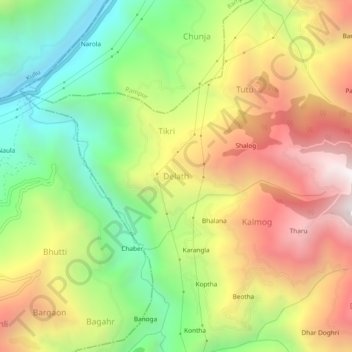
Name: Delath topographic map, elevation, terrain.

Location: Delath, Nankhari, Shimla, Himachal Pradesh, 172030, India (31.31992 77.52253 31.35992 77.56253)

Average elevation: 1,489 m

Minimum elevation: 813 m

Maximum elevation: 2,260 m

Gear up for your next adventure:

Camping Essentials - All-in-one gear for a comfortable camping trip
💧Filtered Water Bottle - Safe drinking water on the go
🧭Orienteering Kit - Tools for map reading and navigation in the wild
🧴Sunscreen SPF - Broad-spectrum sunscreen for outdoor activities
🧢Hiking Hat - Sun-protective and breathable hats for long treks

As an Amazon Associate, this site earns from qualifying purchases at no extra cost to you.