
Make a donation
Gear up for your next adventure:
As an Amazon Associate, this site earns from qualifying purchases at no extra cost to you.
Superior Charter Township topographic map
Click on the map to display elevation.
Make a donation
Gear up for your next adventure:
As an Amazon Associate, this site earns from qualifying purchases at no extra cost to you.
About this map
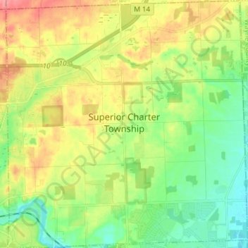
Name: Superior Charter Township topographic map, elevation, terrain.
Average elevation: 248 m
Minimum elevation: 216 m
Maximum elevation: 294 m
Make a donation
Gear up for your next adventure:
As an Amazon Associate, this site earns from qualifying purchases at no extra cost to you.
Other topographic maps
Click on a map to view its topography, its elevation and its terrain.
Mooreville
United States > Michigan > Washtenaw County > York Charter Township
Average elevation: 222 m
Rawsonville
United States > Michigan > Washtenaw County > Ypsilanti Charter Township
Average elevation: 214 m
Rawsonville
United States > Michigan > Washtenaw County > Ypsilanti Charter Township
Average elevation: 214 m
Make a donation
Gear up for your next adventure:
As an Amazon Associate, this site earns from qualifying purchases at no extra cost to you.
Frain Lake
United States > Michigan > Washtenaw County > Superior Charter Township
Average elevation: 259 m
Rawsonville
United States > Michigan > Washtenaw County > Ypsilanti Charter Township
Average elevation: 214 m