Geolocate

Capital topographic map

Click on the map to display elevation.

About this map

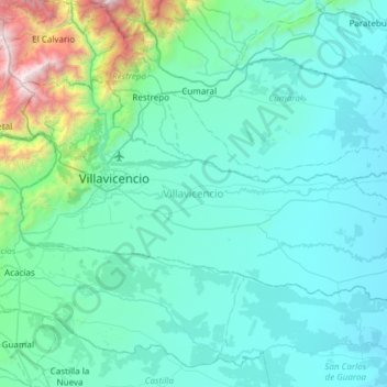
Name: Capital topographic map, elevation, terrain.

Location: Capital, Meta, Colombia (3.93435 -73.76761 4.28823 -73.16570)

Average elevation: 585 m

Minimum elevation: 204 m

Maximum elevation: 3,673 m

Other topographic maps

Click on a map to view its topography, its elevation and its terrain.

Caño Cristales

Colombia > Meta > La Macarena

Average elevation: 290 m

Gear up for your next adventure:

🧥Packable Rain Jacket - Breathable waterproof layer for unpredictable weather
🥾Mountain Hiking Boots - High-traction boots for rocky terrain
💧Collapsible Water Bottle - Space-saving water bottle for outdoor activities
Lightweight Backpacking Tent - Compact tent for efficient hiking trips
💧Hydration Bladder - Hands-free hydration solution for long treks

As an Amazon Associate, this site earns from qualifying purchases at no extra cost to you.