Geolocate

Fayetteville topographic map

Click on the map to display elevation.

About this map

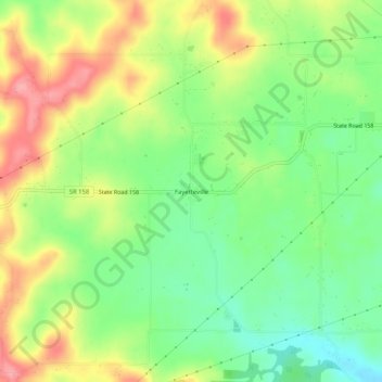
Name: Fayetteville topographic map, elevation, terrain.

Location: Fayetteville, Lawrence County, Indiana, United States (38.84088 -86.61527 38.88088 -86.57527)

Average elevation: 201 m

Minimum elevation: 153 m

Maximum elevation: 262 m

Other topographic maps

Click on a map to view its topography, its elevation and its terrain.

Bedford

United States > Indiana > Lawrence County

Average elevation: 191 m

Mitchell

United States > Indiana > Lawrence County

Average elevation: 209 m

Bedford

United States > Indiana > Lawrence County

Average elevation: 191 m

Gear up for your next adventure:

🧢Outdoor Cap - Protective cap for sun and rain during hikes
🧥Waterproof Jacket - Lightweight rain jackets for hiking and outdoor activities
👖Convertible Hiking Pants - Zip-off legs to adapt to changing weather conditions
🧥Waterproof Hiking Jacket - Protect yourself from rain and wind while hiking
🛏️Camping Sleeping Mat - Comfortable mats for sleeping outdoors

As an Amazon Associate, this site earns from qualifying purchases at no extra cost to you.