Geolocate

Tepoztlán topographic map

Click on the map to display elevation.

About this map

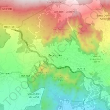
Name: Tepoztlán topographic map, elevation, terrain.

Location: Tepoztlán, Morelos, 62520, Mexico (18.94615 -99.13980 19.02615 -99.05980)

Average elevation: 1,837 m

Minimum elevation: 1,333 m

Maximum elevation: 2,591 m

Gear up for your next adventure:

Camping Coffee Maker - Brew fresh coffee anywhere on the topographic map
🕶️Polarized Sunglasses - Reduces glare from snow and water at high elevations
🥾Trail Running Boots - Durable shoes designed for trail running
🧥Ultralight Puffy Jacket - Maximum warmth that packs down to the size of an orange
🧤Rechargeable Heated Gloves - Extreme warmth for Canadian winter expeditions

As an Amazon Associate, this site earns from qualifying purchases at no extra cost to you.