
Make a donation
Gear up for your next adventure:
As an Amazon Associate, this site earns from qualifying purchases at no extra cost to you.
Porto Sokhna topographic map
Click on the map to display elevation.
Make a donation
Gear up for your next adventure:
As an Amazon Associate, this site earns from qualifying purchases at no extra cost to you.
About this map
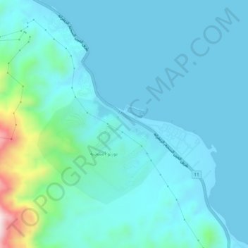
Name: Porto Sokhna topographic map, elevation, terrain.
Location: Porto Sokhna, Suez, Egypt (29.42190 32.46396 29.46190 32.50396)
Average elevation: 67 m
Minimum elevation: -1 m
Maximum elevation: 509 m
Make a donation
Gear up for your next adventure:
As an Amazon Associate, this site earns from qualifying purchases at no extra cost to you.
Other topographic maps
Click on a map to view its topography, its elevation and its terrain.
Suez Canal
Despite the construction challenges that could have been the result of the alleged difference in sea levels, the idea of finding a shorter route to the east remained alive. In 1830, General Francis Chesney submitted a report to the British government that stated that there was no difference in elevation and…
Average elevation: 39 m